
As Air travel becomes more affordable today, the increased overseas travel has facilitated the spread of infectious diseases which will endanger citizens at home and abroad. To assist epidemic control personnel in comprehending epidemic situation of dengue fever, Centers for Disease Control, Taiwan develops an epidemic situation management system to assist in avoiding delay in any reporting of dengue fever and mastering the epidemic situation.
Situated in subtropical zone, dengue fever has gripped Taiwan in recent years. In order to take control of the epidemic throughout the country, the project aims to help CDC develop an epidemic situation management system by means of sever GIS software, store information of the infected patients and locations where dengue fever occurred, understand epidemic situation in each district, and then clearly distinguish whether the dengue fever is mainly caused by vector mosquito habitats.

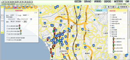
The epidemic situation management GIS system ensures the infection control personnel to report dengue fever infection situation anywhere after logging into the online system and consequently employ map display and diverse analysis functions to determine the mutual relations among dengue fever occurrence, locations and vector mosquito habitats.

In this project, SuperGIS Server 3.1 was utilized as the GIS platform core to distribute and manage map information and build map websites. The server GIS allows developers to apply customization functions, Jquery and Javascript syntax to create their own map websites with interactive visual effects. Besides, the system adopts Microsoft SQL Server 2008 as the database management software to manage spatial-related indices and statistic information for efficient data querying.
Serving to integrate legal infectious disease cases with the location where diseases caused, the Epidemic Situation Management GIS System enables relevant departmental executives to access the information about controlled area of mosquito habitats, vector mosquito indices, position of public location, etc; meanwhile utilizing the accurate references to formulate disease prevention plans to combat the threat of communicable diseases and safeguard the life and health of the citizens.
More information about the application story, please visit http://www.supergeotek.com/Library_2_201212.aspx
More product information about SuperGIS Server 3, please visit
http://www.supergeotek.com/ProductPage_SGS3.aspx
No comments:
Post a Comment